Monday, June 16, 2025
Home Blog Page 23

Open sources show airstrike damages despite post-earthquake ceasefire

0
Images show that large parts of Indaw were destroyed last year. (Credit: Google Earth Pro Imagery)

Bellingcat has identified at least 22 villages damaged by airstrikes in Myanmar, despite a temporary ceasefire declared by the State Administrative Control (SAC) or the military junta from April 2 to 22 following a 7.7 magnitude earthquake that hit the country on March 28. The ceasefire has been extended to April 30.

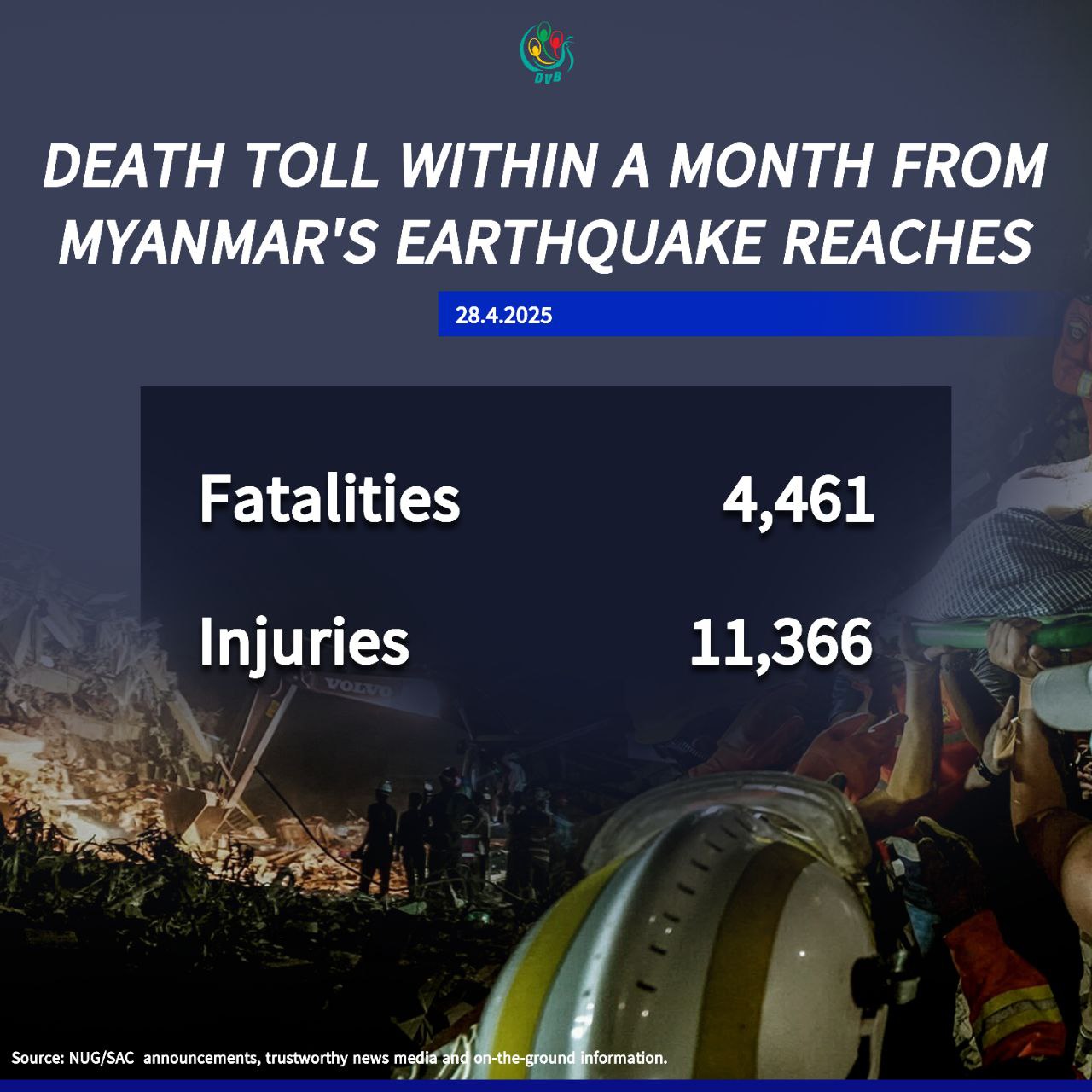
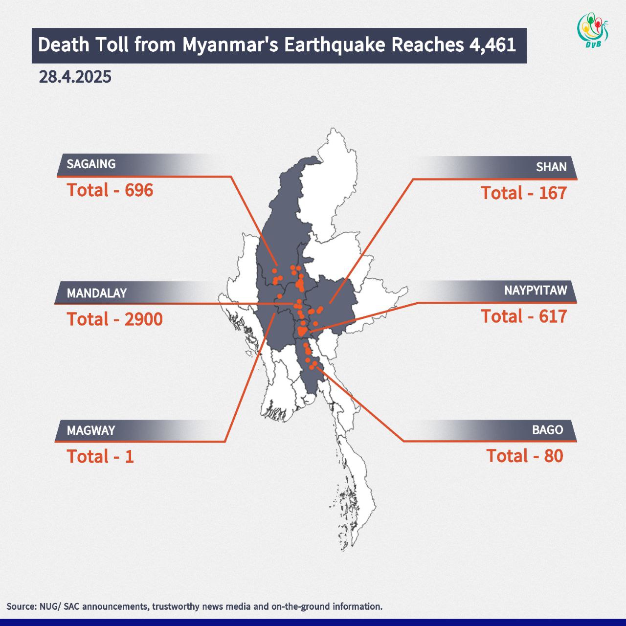
The earthquake’s epicentre was recorded just 16km northwest of Mandalay, the second-largest city in Myanmar, and it struck just before 1pm local time. More than 3,000 people died and aid groups report that over 17 million people living in earthquake-affected areas are in urgent need of food, water, shelter and healthcare.

The country, which has already been devastated by four years of civil war, continues to be hit with multiple aftershocks. The SAC, ruling Myanmar since seizing power from the democratically elected government in 2021, declared a temporary pause to fighting only after the main opposition coalition announced one – except in the case of defensive actions. 

Bellingcat has geolocated at least 19 villages damaged in military assaults during the first 20 days of the ceasefire. Two of them were identified from ground reporting. Three additional villages were damaged after the earthquake but before the ceasefire – bringing the total to 22 villages.

The airstrikes targeted civilian areas in territory held by rebel forces and territory where the junta is fighting to regain control. The villages damaged after the ceasefire were geolocated by cross-referencing our findings with NASA FIRMS or satellite imagery alongside local and other media sources.

“It’s quite clear that only the military can do airstrikes. The rebels don’t have aircrafts,” Aye Chan Naing, co-founder and editor-in-chief of Democratic Voice of Burma (DVB), one of Myanmar’s largest independent media organisations, told Bellingcat.

Lacking jets or fighter planes, resistance groups heavily rely on commercial drones “improvised into sort of military use,” Naing said.

Targeting and scaring civilians is part of the military’s strategy, he explained. “If you support the rebels, then you know we [the military] are going to burn the village.”

“At a moment when the sole focus should be on ensuring humanitarian aid gets to disaster zones, the military is instead launching attacks,” said U.N. Human Rights Office spokesperson Ravina Shamdasani on April 11.

“Since the earthquake, military forces have reportedly carried out over 120 attacks – more than half of them after their declared ceasefire was due to have gone into effect on 2 April,” she told journalists.

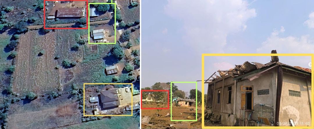
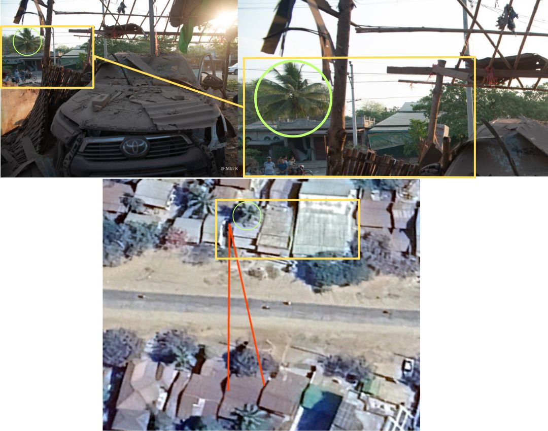
According to local media reports, the Myanmar military carried out an aerial attack just hours after the earthquake struck. Anti-junta armed group, the Ta’ang National Liberation Army (TNLA), claimed that the military bombed Nawng Len village, approximately 120 km from the earthquake’s epicentre in the eastern Shan State. Seven members of a TNLA-aligned ethnic armed organisation (EAO) were reportedly killed in the attack.

We were not able to independently confirm the airstrike, but we were able to geolocate images of several damaged buildings, to a location in the north of the village. The intact buildings can be seen on Google Earth imagery in late January.

Left: Location of the village on Google Earth. Right: Photos of Nawng Len after the attack. (Credit: The Irrawaddy)

The military junta did not respond to Bellingcat’s request for comment.

Attacks in Worst-Affected Earthquake Areas

Out of the 22 villages we identified, 14 of them are in either Sagaing or Mandalay, which were some of the worst affected areas by the earthquake. Large parts of both regions are located in central Myanmar, where a lot of townships are either contested or under junta control.

The military tries to cut the rebels’ survival pipeline, Naing told Bellingcat.

“They understand that the rebels cannot survive without civilians because that’s where they get food and maybe tax money,” he said.

Since the rebels don’t have permanent bases, members are difficult to locate. While drones might strike and kill a few individuals, it’s much easier for the army to identify and target areas where civilians live, Naing added.

On April 9, twenty people were reportedly killed in an airstrike in Nan Khan in Sagaing’s Wuntho Township. We were able to geolocate images of damaged buildings to the coordinates 23.9983922,95.8881422.

Left: Image of houses damaged in Nan Khan, (Credit: Khit Thit Media); Right: Location on Google Maps

Just days before this attack, on April 6, Thone Pan Hla in Chaung-U Township was reportedly attacked in an airstrike, killing three members of a family. “The motivation for such an attack on a village of melon farmers is difficult to understand. It seems to be an effort to terrorise a civilian population that strongly supports the anti-regime National Unity Government (NUG) and its armed rebel (People’s Defense Force) wing,” reported The Times newspaper. NUG is the country’s parallel government in exile, elected democratically and ousted in the 2021 coup.

About 25 km northeast of Thone Pan Hla is the village of Ngar Shan also in Chaung-U Township. Local news outlets reported that the village was burned down by the junta, just days after the earthquake. While we weren’t able to geolocate specific images or independently confirm the cause of the fire, thermal hotspots were detected at the site on March 31. This lines up with the timeline and reports of 170 houses being burned in Ngar Shan on April 1 local time.

Images of the destruction shared on Facebook show the village in ruins. However, NASA’s Fire Information for Resource Management System, FIRMS, detects thermal hotspots in the entire village in the early hours of that day.

Source: NASA FIRMS, March 31, 2025 UTC

A false-colour infrared map from Sentinel Hub’s Copernicus platform also reveals signs of destruction in the village. Though commonly used to assess vegetation health, this type of imagery shows plant-covered areas in deep red, while cities and exposed ground are grey or tan, and water appears blue or black. Following the attack, exposed ground, indicative of possible damage, can be seen primarily in the northwest of the village.

Source: Sentinel Hub’s Copernicus platform

Chaung-U Township is located in the southern Sagaing Region, where the geography poses challenges for resistance armies.

“Unlike ethnic resistance groups along Myanmar’s borders, or those in northern Sagaing near India, the resistance forces in southern Sagaing do not have foreign borders across which they can attempt to retreat,” wrote Centre for Information Resilience’s Myanmar Witness in a December 2024 report. 

Sagaing remains an epicentre for violence with a strong resistance presence due to the region’s strategic importance. A state of emergency was declared in the state following the quake.

Repeated Bombings in Lost Territories

Another region of strategic importance is Mandalay where the Central Military Command is located in the Mandalay Palace, reported to have been damaged in the earthquake. Mandalay is also a logistical hub in Myanmar’s heartland, and since late last year, the SAC has been trying to retake townships it has lost there. 

Two of those townships are Thabeikkyin and Singu. Both were attacked during the ceasefire. 

On April 19, the Myanmar military reportedly carried out an airstrike on the village of Yae Htwet in Thabeikkyin Township. The attack killed at least 27 people, according to the BBC. The report added that pro-military Telegram channels claimed the attack targeted PDF camps, the armed wing of the anti-regime National Unity Government. 

Just a day earlier, 13 people were reportedly killed in an attack on Leik Kya village, located 3 km north of Yae Htwet.

A separate aerial attack was reportedly carried out over a village in Thabeikkyin, killing two people. It took place on April 13 in Chaung Gyi along the highway running through the village. We were able to identify distinct features of the roof of buildings across the street from the attack and, along with the location of trees, match satellite images of the area.

Above: Photo of the damage in Chaung Gyi, (Credit: Khit Thit Media); Below: Location on Google Earth

Bellingcat also geolocated a school (here: 22.689505, 96.016978) in Singu Township, the site of a reported airstrike in Kyi Tauk Pau village that injured six people.

Destruction of Schools and Religious Sites

The junta has a track record of targeting schools. According to a tally by Radio Free Asia last November, nearly 200 schools were hit by airstrikes since the 2021 military coup in regions and states which have seen fighting by resistance forces opposing junta rule.

A school in Sagaing’s Shwebo Township was reportedly bombed during the ceasefire on April 20, killing two people, including a pregnant woman. According to DVB, Shwebo Township People’s Administration, a local anti-junta governance body, said displaced people were taking shelter in the school.

Bellingcat found four schools and seven religious sites – monasteries and churches – damaged in recent attacks.

Peter Bouckaert of the human rights and advocacy group Fortify Rights called the attacks on churches and monasteries that could be hosting people displaced by the earthquake “a great violation of the laws of war”.

“These are protected sites under international humanitarian law. They are direct deliberate attacks on these protected institutions,” he told Bellingcat.

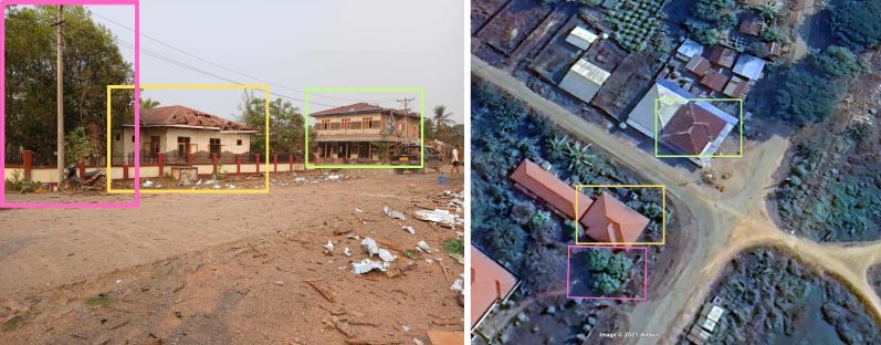
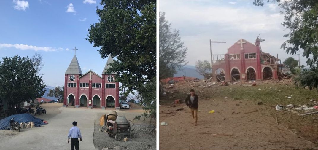
The junta has a history of attacking religious sites. During the ceasefire, a Baptist church was bombed in Mindat in the neighbouring Chin State, where several armed opposition groups have emerged since 2021. While there were no reported casualties at the church, six people were killed in the attack on the town.

The Baptist Church in Mindat before (left, source: bruno.assaz/wikiloc) and after (right, credit: Tachileik News Agency) the attack

Mindat was taken over by resistance forces last year amid reports of hundreds of homes destroyed by alleged junta shelling, arson, and airstrikes. A lot of this damage is now visible on Google Maps’ updated imagery from January 2025.

Several churches in Chin State have been damaged in the past few years, Myanmar Witness had found in 2023. It is the only Christian-majority state in Buddhist-majority Myanmar.

Battle for Control of Town Rages Amid Ceasefire

Indaw is a small town close to the border with Kachin State, a state partly controlled by the Kachin Independence Army (KIA)-led resistance forces. Indaw was reportedly bombed on April 1 when it was still under the junta’s control. According to local accounts, two people were killed and eight others injured. A monastery was damaged in the attack. We were able to geolocate the images of the aftermath by comparing old pictures and satellite images of the monastery with structures still standing after the recent attack.

Left: Before image of the monastery, (Credit: Kachin News Group); Right: Photo of monastery after the military’s attack (Credit: Indaw Revolution-IR); Middle: Location on Google Maps

The destruction on April 1 was just one of the many assaults the town has witnessed since resistance forces launched an offensive in August last year. The junta’s reported airstrikes against the resistance displaced hundreds of people, and many others fled. 

Despite the ceasefire, on April 8, resistance forces captured Indaw after months of fighting. However, the junta has continued to carry out airstrikes in civilian areas, according to reports. As Richard Horsey, Senior Adviser on Myanmar at Crisis Group, previously told Bellingcat, the junta often bombs areas it has lost so people have nothing left to return to.

Images show that large parts of Indaw were destroyed last year. (Credit: Google Earth Pro Imagery)

Attacks During Burmese New Year

The military regime reportedly carried out airstrikes on monasteries over the four-day Thingyan or Burmese New Year festival from April 13 to 16. According to data compiled by an independent news site, The Irrawaddy, at least 23 civilians were killed in these attacks.

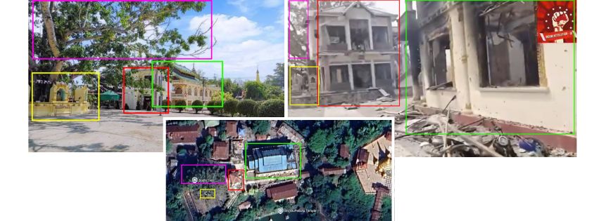
In one of the monastery attacks, six people were reportedly killed and 20 others injured. Bellingcat geolocated the aftermath of the reported strike. This was in Kan Ni village in Kawkareik Township in Kayin (Karen) State, one of the southernmost states of the country.

Left: Screenshot from a video capturing damage in the monastery, (Credit: Independent Mon News Agency); Right: Photo of the monastery on Google Maps

Despite Widespread Violations, Junta Extends Ceasefire

The Myanmar military has now extended the ceasefire to April 30 in a move to “expedite relief and rebuilding efforts”, but reports say that aid is being restricted. “The SAC is weaponising humanitarian assistance,” Surachanee Sriyai, interim director at the Center for Sustainable Humanitarian Action to Displaced Ethnic Communities, told Bellingcat, explaining that aid is not reaching areas that aren’t under the SAC’s control. An analysis by the BBC in November last year reported that the military only has full control of 21 percent of Myanmar’s territory. 

Sriyai noted that while the earthquake has drawn some attention to Myanmar, the country has already been in critical need of aid due to the prolonged armed conflict. Meanwhile, bombings persist even during the extended ceasefire period.


Members of Bellingcat’s Global Authentication Project, including Afton Knox, Nicole Kiess, Stéphanie Ladel, and Max F. Wan contributed research to this piece. Interactive map by Miguel Ramalho.

Bellingcat is a non-profit and the ability to carry out our work is dependent on the kind support of individual donors. If you would like to support our work, you can do so here. You can also subscribe to our Patreon channel. Subscribe to our Newsletter and follow us on Bluesky, Instagram and YouTube.

Strengthening global partnerships for Myanmar’s democratic future

0
A Myanmar journalist reads about the termination of funding for Radio Free Asia on its website on March 20. (Credit: DVB)

Guest contributor

James Shwe

The recent operational pause of Voice of America (VOA) and Radio Free Asia (RFA) Burmese language services, following a U.S. government review of federal agency funding, has sparked important discussions about the role of independent media in regions where press freedom is under siege. 

As the U.S. recalibrates its global media engagement to meet emerging challenges, this moment highlights a pivotal opportunity for democratic nations worldwide to unite in supporting access to truthful information and humanitarian aid for Myanmar—particularly in the wake of the devastating March 28 earthquake and the military junta’s ongoing repression.

The role of independent media in Myanmar

For decades, VOA and RFA have provided millions in Myanmar with uncensored news, offering a critical counterbalance to state-controlled narratives. 

Their reporting on human rights abuses, governance, and regional affairs has empowered communities to make informed decisions, even as the junta tightened censorship after the 2021 coup. 

The temporary suspension of these services, pending legal and congressional review, underscores the need for robust international collaboration to ensure continuity in truthful reporting.

A federal judge recently ordered the restoration of funding for VOA and RFA, reaffirming their congressionally mandated mission to deliver “accurate, objective, and comprehensive” journalism. 

This legal victory reflects bipartisan efforts to preserve essential tools of U.S. soft power, which have long fostered global trust in democratic values.

Myanmar’s dual crisis: Earthquake and authoritarian control

The devastating March 28 earthquake, which killed thousands and displaced millions, has compounded Myanmar’s humanitarian and political crises. 

The junta has restricted aid to resistance-held areas, diverted relief funds to military operations, and staged propaganda campaigns to legitimize its rule. 

Meanwhile, China has expanded its influence, pressuring ethnic armed organizations to surrender key territories and flooding Myanmar’s information space with state-backed narratives.

Propaganda and disinformation have become central to the junta’s strategy, distorting public opinion and undermining resistance efforts. While Myanmar’s majority population remains firmly opposed to military rule, an increasingly fractured information ecosystem has left many vulnerable to manipulation. 

Investment in critical thinking education, paired with broader media access, can help empower citizens to dismantle authoritarian narratives and strengthen national unity. However, these efforts must be accompanied by strategies addressing tech platform accountability, media freedom, and grassroots mobilization.

China has further complicated Myanmar’s path to democracy by providing diplomatic cover for the junta’s planned sham elections, widely condemned as a facade to entrench military rule. 

This approach enables Beijing to prolong the conflict while securing strategic advantages, such as preferential access to Myanmar’s resources and infrastructure projects under the Belt and Road Initiative.

In this environment, the international community faces an urgent responsibility: to ensure humanitarian aid reaches those in need and to prevent authoritarian narratives from dominating the discourse.

A call for global democratic solidarity

The U.S. has historically been a leader in supporting democracy and human rights in Myanmar, providing more than $400 million USD in assistance since the 2021 coup. As Washington reevaluates and strengthens its global media strategy, democratic partners can reinforce these efforts by:

  1. Emergency support for independent media:
    Democracies such as the E.U., Japan, South Korea, and others should provide transitional funding and technical assistance to sustain alternative and local Burmese media outlets. Initiatives already proposed by countries like the Czech Republic and Germany to support independent journalism offer a promising model.
  2. Humanitarian aid through trusted channels:
    International donors should prioritize partnerships with Myanmar’s National Unity Government (NUG), ethnic organizations, and civil society groups to deliver earthquake relief directly to communities, bypassing junta-controlled distribution networks.
  3. Countering authoritarian disinformation:
    Democracies must invest in Burmese-language media initiatives to counter the growing dominance of Chinese state outlets such as Xinhua and China Radio International (CRI), which now produce more Myanmar-focused content than any other foreign broadcasters.
  4. Diplomatic pressure on the junta:
    The Association of Southeast Asian Nations (ASEAN), the U.N., and other international actors must intensify demands for humanitarian ceasefires and accountability for aid obstruction, while urging China and others to respect Myanmar’s sovereignty and democratic aspirations.

Why this matters for democracy

The people of Myanmar continue to aspire to values of transparency, accountability, and self-determination—principles that resonate deeply with all democracies. As global media dynamics shift, international solidarity can ensure that access to truthful reporting and life-saving aid remain steadfast pillars of support for Myanmar’s democratic resistance.

The restoration of VOA and RFA, as mandated by U.S. courts, will be critical to these efforts. As RFA President Bay Fang rightly stated: “Our audiences deserve access to facts, not propaganda.”

By working together, democracies can uphold this vision and ensure Myanmar’s people are not left in the dark. 


James Shwe is a Myanmar democracy activist in the U.S. and is a member of the advocacy groups Free Myanmar and the Los Angeles Myanmar Movement. He has been trying to organize and motivate the Myanmar diaspora to advocate for democracy in Myanmar.

DVB publishes a diversity of opinions that does not reflect DVB editorial policy. We’d like to hear what you think about this or any of our stories: [email protected]

One month after the Myanmar earthquake fundraiser

0
One month after the earthquake was a fundraising event held at Lan Din in Chaing Mai, Thailand, on April 28. (Credit: DVB)

An event called “One month after the earthquake: Solidarity for Hope” raised funds for earthquake relief in Myanmar – one month after a devastating 7.7 magnitude quake struck that killed over 4,000 people – was held at Lan Din in Chiang Mai, Thailand, on April 28.

“This fundraising is going to the Myanmar [civil society] groups that are based here in Chiang Mai. They are volunteers that are connected with the [aid workers] and organizations on the ground,” said Pi Ae, the event’s organizer.

All proceeds will go to the Myanmar Earthquake Response Coordination Unit, which was established on March 29 to provide relief to the hardest-hit regions of Sagaing and Mandalay, as well as southern Shan State’s Inle Lake.

Dancers in northern Thailand set Guinness World Record

0
Dancers in Chiang Mai, Thailand, set a Guinness World Record for the largest traditional Thai dance to celebrate the city’s 729th anniversary at the Three Kings Monument on April 19. (Credit: DVB)

Dancers in Chiang Mai, Thailand, set a Guinness World Record for the largest traditional Thai dance. It was to celebrate the city’s 729th anniversary. The event was held at the Three Kings Monument on April 19.

A People’s Defence Force splits with National Unity Government; UN aid corridor into Rakhine State proposed

0
The People’s Defence Force Battalion 2 of Kyaukse District, Mandalay Region, shared a photo of its members in front of the Nawnghkio town gate in northern Shan State on July 28. (Credit: PDF)

A People’s Defence Force splits with National Unity Government

The People’s Defence Force (PDF) Battalion 2 in Kyaukse District of Mandalay Region told DVB that it submitted its resignation letter and is awaiting National Unity Government (NUG) Ministry of Defence approval to withdraw on April 22. Sitt Naing, the interim PDF battalion commander, told DVB that it will return the 45 firearms issued by the NUG once it accepts the PDF withdrawal.

He added that the PDF will now fight alongside the Danu People’s Liberation Army (DPLA), which operates in southern Shan State. A PDF spokesperson told DVB that although they received  weapons, ammunition, and financial support from the NUG, there has recently been discriminatory treatment between battalions but did not provide further details. 

Kyaukse District Battalion 2 was established as a PDF in 2022 following the 2021 military coup. It became a battalion under the command of the NUG Ministry of Defense in February 2023. It has reportedly participated in over 50 battles alongside resistance forces, including the Ta’ang National Liberation Army (TNLA) in Shan State, as well as Sagaing, and Mandalay regions.

UN aid corridor into Rakhine State proposed 

The interim government of Bangladesh Foreign Advisor Md. Touhid Hossain said that the Ministry of Foreign Affairs in Dhaka had agreed in principle to a U.N. proposal to establish a humanitarian aid corridor from Bangladesh into Arakan State. He added that the agreement is conditional and did not disclose further details except that it would be a “humanitarian passage.”

“A large population from Myanmar has taken refuge in our country, and we want to repatriate them. We must do whatever is necessary to facilitate their return,” Hossain told the media on Sunday, adding that the 168 mile (271 km) long Bangladesh-Burma border is under the control of a “non-state actor,” referring to the Arakan Army (AA).

Md. Touhid Hossain wants Bangladesh to have “some form of communication” despite not being able to formally communicate with the AA, which took control of the border when it seized Maungdaw Township in northern Arakan on Dec. 8. It now controls 14 of 17 Arakan townships since it launched its state-wide offensive in November 2023

The Ambassador of Japan to Bangladesh Saida Shinichi during a visit to a Rohingya refugee camp in Cox’s Bazar on April 20. (Credit: IOM)

Japan to provide $3.5 million to Rohingya refugees in Bangladesh

The government of Japan has pledged to provide $3.5 million USD in assistance to the International Organization for Migration (IOM) to improve the living conditions of 500,000 Rohingya refugees and individuals from the host communities in Cox’s Bazar district and Bhasan Char, an island off the coast of Bangladesh.

“I’m hopeful this comprehensive plan will improve the living conditions for Rohingya refugees and host communities both in Cox’s Bazar and Bhasan Char,” said Saida Shinichi, the Ambassador of Japan to Bangladesh, in a press release on April 27. Site management and development, protection, shelter and non-food items were included. 

The funds will go toward liquid petroleum gas distribution, water, sanitation and hygiene, as well as livelihood support for refugees in Bhasan Char and disaster risk reduction and protection services for host communities in Cox’s Bazar. Since 2017, Japan has contributed over $250 million USD to the Rohingya refugee response in Bangladesh.

News by Region

MAGWAY—The PDF in Salin Township told DVB that it killed at least nine regime troops during an ambush on a 200-strong military column that tried to enter areas under PDF control on April 24. It added that one PDF member sustained minor injuries during fighting. 

Salin is located 46 miles (74 km) northwest of the region’s capital Magway. Resistance forces claimed that it killed at least 20 regime troops during an ambush in Salin on April 19.

TANINTHARYI—Dawei Township residents told DVB that two civilians were killed and three others were injured by air and artillery attacks after the Karen National Union (KNU) seized a regime outpost along Dawei-Kaleinaung road in Maungmaeshaung village on Saturday. 

“The military returned fire with artillery and carried out airstrikes, killing a couple and destroying a monastery,” a resident told DVB on the condition of anonymity. A KNU spokesperson claimed that 15 military personnel were arrested and weapons were seized by resistance forces. 

(Exchange rate: $1 USD = 4,410 MMK) 

How a ‘supershear’ earthquake tore through Myanmar

0
Piles of flip-flops are seen following a strong earthquake in Amarapura Township, Mandalay Region, on April 4, 2025. (Credit: Reuters)

Data reveals why last month’s earthquake was so devastating

The ground in Myanmar was split and dragged in different directions during the massive 7.7 magnitude earthquake that hit the Southeast Asian nation on March 28. The quake tore a rupture through the earth’s surface stretching for more than 285 miles (460 km), around twice the distance expected from a quake of this magnitude, according to scientists.

This reveals how much the surface moved in opposite directions during the quake, using data from the U.S. Geological Survey (USGS). The long surface rupture can be plotted along the contrasting sections of land, which shifted around 5 metres (16.4 feet) in different directions, according to the analysis.

The quake has killed more than 3,700 people, flattened communities and crippled infrastructure in the impoverished nation.

A month after the quake hit, nearly 200,000 people remain displaced and living outdoors, according to the International Federation of Red Cross and Red Crescent Societies (IFRC), even as parts of central Myanmar are jolted almost daily by aftershocks.

“Myanmar’s cyclone season starts within days, exposing coastal populations to strong winds and rains – leaving families to face the risks of floods and landslides,” IFRC said on Monday. “Conditions on the ground continue to be very challenging.”

The monsoon rains typically arrive in Myanmar by late May, possibly piling more misery on the displaced.

Supershear

The speed of the massive rupture may have also played a role in the devastation. Scientists believe this was a “supershear” earthquake, a rare event where the rupture in the ground moved faster than the seismic waves produced.

“Preliminary studies indicate that the rupture was supershear,” said Dr. Judith Hubbard, Professor at Cornell University and co-founder of Earthquake Insights.

Earthquakes begin at a specific point on a fault and spread rapidly along it, usually at speeds of a few miles (km) per second. In this instance, scientists observed that the rupture spread even faster than usual.

“When an earthquake occurs, it does not happen all at once,” said Hubbard. The rupture constantly creates waves of energy that spread like ripples in a pond. If the rupture moves faster than these waves, they can pile up and form a Mach wave, similar to the sonic booms from supersonic jets, she told Reuters.

Sub-shear rupture

Energy is released at various points along the rupture as it moves.

The supershear effect may have led to greater damage at greater distances than typical earthquakes, with significant structural failures observed as far away as Bangkok in neighbouring Thailand.

“Supershear ruptures generally result in longer than expected earthquakes, which means shaking occurs over a larger area compared to other earthquakes of the same magnitude,” said Steven Sobieszczyk, scientist at USGS.

Record rupture

“One of the things that stands out about this earthquake is its length,” said Hubbard, who believes it is the longest M7.7 earthquake rupture ever recorded.

Data from USGS indicates the rupture was about 174 miles (190 km) longer than that of the massive earthquake which struck Turkey and Syria in February, 2023, killing more than 55,000 people.

“This was an abnormally long earthquake,” said Sobieszczyk. He explained that the rupture length was approximately double what is typically expected for its magnitude.

The maps below show the size of the rupture relative to other well-known land masses. The crack is comparable to the length of Taiwan, South Korea, or Portugal.

Connecting the dots

For smaller earthquakes, a point on a map is sufficient to depict the epicentre, where the quake originates. However, large earthquakes, like the one in Myanmar, with ruptures extending hundreds of miles, impact areas far away from the epicentre.

The smaller towns situated along the rupture suffered some of the most severe shaking as it tore straight through some of these settlements, along with the capital, Naypyidaw, as if it were joining the dots on a map.

The rupture is visible in satellite imagery at some locations along the fault, such as the following location on the outskirts of Naypyidaw.

Across Myanmar, the quake damaged thousands of structures and crippled critical infrastructure, even bringing down parts of its purpose-built capital city Naypyidaw.

Nationwide, it damaged over 400 roads, 300 hospitals and clinics, 95 bridges, 2,500 schools and 55,000 houses, totaling about $1.9 billion USD worth of losses as per current estimates, according to the Association of Southeast Asian Nations – ASEAN Coordinating Centre for Humanitarian Assistance on Disaster Management.

The military regime is now working to rebuild some government buildings to withstand earthquakes of up to 8 magnitude, regime media reported last week.

More than 1,000 buildings were damaged in Mandalay alone, the city close to the epicentre, according to a damage assessment by the U.N. – United Nations Satellite Centre. About 900 other buildings were found to be possibly damaged.

Further south in the Thai capital, Bangkok, the quake killed at least 63 people, including 56 after an under-construction building collapsed. Thai authorities are still working to clear the debris at the site, where 38 people are still missing.

Despite Bangkok being 620 miles (1,000 km) from the epicentre, it is only 416 miles (670 km) from the southern end of the rupture, Sobieszczyk told Reuters. He also noted that the earthquake ruptured predominantly from north to south, channeling stronger shaking towards the city.

The impacts in Bangkok are still being studied, but several factors likely played a role, including Bangkok’s soft sediment which can amplify ground shaking, similar to Kathmandu and Mexico City, Sobieszczyk explained.

According to Hubbard, untangling these issues may take significant work by experts over the coming months to years, looking at the specific waveforms recorded by seismometers in the region.

“Unfortunately, records within Myanmar are very sparse, and south of Myanmar is the Andaman Sea, which also does not have seismometers,” said Hubbard. However, records from within Thailand should provide some insight, she added.

The Earth Observatory of Singapore, a research institute at the Nanyang Technological University, removed two-thirds of its seismic monitors in Myanmar last year because of “logistic difficulty related to the pandemic and the coup”, according to Dr. Shengji Wei, Principal Investigator at the observatory.

Wei explained that they missed the chance to collect strong motion data near the ruptured fault and to monitor seismic activity in the region, including numerous aftershocks.

REUTERS

Feel the passion for press freedom ignite within you.

Join us as a valued contributor to our vibrant community, where your voice harmonizes with the symphony of truth. Together, we'll amplify the power of free journalism.

Lost Password?
Contact